Monday, October 27, 2014

Into the fall Part II


Into the Fall Part II

In part one I wrote of “Waiting 5 minutes for the weather to change” and how truly how unpredictable the weather can be, especially if you have to plan your trips almost a year in advance.
This year’s choice of the week of October 4th to 11th was full of possibilities, full moon fall colours and a lunar eclipse.  It was the same week chosen as the last 3 years which where all exceptional weather wise.  Well, this year the Big Lake showed who was in charge of the area.


Usually I am just hoping for enough rain to raise the river levels a bit so you can get down with some “Bump and Grind” but the rains brought the levels up more than 1 metre from what I usually run. 
I had a rookie wilderness tripper with me, and the high river levels where just not safe to take him down on a canoe trip.  I will post a link to our trip at the bottom so you can follow our adventure.
The storms of November came early to Gitchigumi this year and photo opportunities still abound, the difference is with the speed of the weather systems and the more “challenging” conditions you as a photographer have to be and get ready much faster. 
One of the benefits of the high water is that all the hidden small streams with waterfalls in the Algoma Highlands become beautiful cascades that demand that you stop and enjoy them.


What is normally passed by becomes a scene that is painted with water.


Some scenes show the power of water unleashed.  This shot of where Eleven Mile Creek meets the Agawa River; it is as if the water is being ejected from the top of the canyon walls.


Other better known falls take on a different appearance such as this shot of South Black Beaver falls.  The colour in the leaves, ground vegetation, and rocks is really brought out by a recent rain/snow squall.  It gives the falls a very “soft” look, but also lets you know that the temperature is very cool.


As for landscape shots you have to be a lot luckier to get conditions that will really showoff the terrain of the area.  Sometimes it’s hard to get the whole scene into your frame with what your eyes see.  Too much of one background colour, be it either clear sky or clouds.  In this image from the observation platform at Canyon Station Park it all comes together to show the beauty and depth of the Canyon.


When you are hanging out in a specific area you know what you want to shoot, it then becomes a matter what will the weather bring.  Some of the previous shots are good others are just ok, and a mental note to come back and try another day.  In the base camp scenario you can get that chance of getting that special shot.  
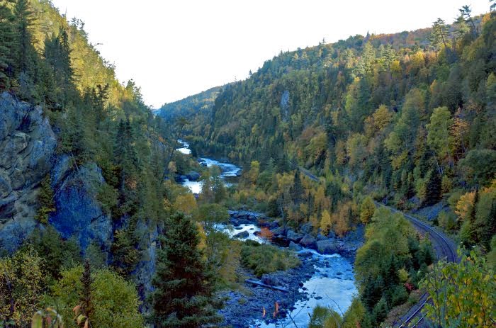
I knew I wanted to get the ACR Passenger train in the A.Y Jackson painting location.  This is a spot I have always climbed up too, even before I knew it was a G7 location.  Ever since I first came to the Canyon, no matter what the conditions I have always sat there for a while, just absorbing the view. (It is the background image for this blog)
Link to the A.Y. Jackson painting.


I had nothing better to do, no place to go, (which is sort of an oxymoronic  statement when you love being out in the wilderness )  and we where in between squalls, I was having a snack just enjoying the view after the train went by when on of those magic moments happened.  A little hole opened in the clouds and let some light beams in to the canyon.  Just so you know I shoot in raw, I will sharpen, or take some shadows out, reduce highlights, I do not like to over process or process 3 or 4 shots to into one image.  What you see in the image is what I see, and if you go there and encounter similar conditions you will see it too! And this was one of those wow moments; just complete eye candy when Mother Nature shows you her best.


On our last day while waiting for the train to take us back out, we where again given a glimpse of fall beauty when a few more sun beams broke into the canyon.


We thought that was it for photo opportunities for the trip we got showered and a fire going for our last night in Lake Superior Park at the Agawa Bay campground when one of the famous Agawa Bay sunsets started to happen.  A thin sunbeam of light started illuminating the Montreal Harbour Point to the south of us and then to slowly proceed moving north to our location. 


What made this one truly spectacular was the colour the sun was projecting on to the hills along the shore.  Even though many of the maples where now bare, it really showed off what kind of trees grow at what elevation on the hills and where the heavy frosts first hit.


As the sun beam moved north and got lower in the horizon a beautiful gold hue was cast along Agawa Bay.


I was so intent on shooting to the south I almost missed a great natural phenomenon.  My wife pointed out that there was something different between the Agawa Islands and the mainland point where the pictographs are; it was a mirage, most likely the islands that are in that direction approximately kms. from where we where.


We now know how mirages work but did this effect have any influence on their drawing on Agawa Rock.


The few people that where on the beach that evening where all golden, even the White Pines along the beach where golden.  To have  the area painted in such an amazing way just left you in awe.


There was a lot of “ifs” on this trip, if any of these didn’t happen, I would have missed out on some spectacular shots.  What if the river did not rise to flood levels?  What if the first train we where to take in on the Saturday was not cancelled?  What if we decided not to go or bail early on the trip?  Any one change in what we did and we would have missed it all. 
When you experience such beautiful phenomena and landscapes in this area you have to wonder if the spirits of the area had anything to do with what transpiried.
I am beginning to think they are watching!

Jeff

Link to trip report.

Link to album.

Monday, September 15, 2014

Into the Fall


It is that time of year where if you wait 5 minutes the weather is going to change, especially in Northern Ontario. So just a short blog to inspire you to get out and enjoy the fall season.

From the Mouth of the Agawa River
Looking Northeast.


Sometimes the weather is warm and calm and other times it can be downright nasty.  You have to not only respect the terrain but be prepared for what the season will through at you.
In the fall the Algoma region is incredible eye candy!
If you are taking photos you may be offered only short time span in which to "catch" the perfect frame, a sun beam, a intriguing cloud pattern or a shadow or shape.
But sometimes just to sit and watch the show unfold knowing that your front row seat is one of a kind and the camera will just not do the scene justice.

From the Towab Trail


This next image is was taken several years ago  but I felt was a good example to go along with the segments from radio show I have linked below.   from such a big vista like Agawa Canyon there is some much more you can see, and this little tree tells us a lot.


I heard this on on Sunday September 14 and I thought it would be good to share, not only from a photographers mind set, but also from the view that if you want to slow the world and notice "other happenings" that are taking place around you.
It will also open your mind to see other perspectives in areas that are heavily photographed or visited.
It has some good suggestions that will encourage to practice more for those times that you do get go to special places like Northern Ontario
CBC Radio 1, Tapestry; Season 20, Episode 2.
http://www.cbc.ca/tapestry/
Starts At 36:30


Thursday, August 21, 2014

Sunsets of Superior


Sunsets of Superior.


The Coast of Lake Superior from Sault Ste. Marie to Thunder Bay is an amazing place.  Many of those who have visited, return time and time again.  What makes this coast even more amazing is that for as rugged and remote it is, it can be  accessed  by almost everyone!

We will start this off with a disclaimer and warning.
When shooting sunsets all precautions should be taken to avoid looking into the sun.
Failing to do so can cause eye damage or blindness.  There are various techniques to do this and it is worth the research to protect your eyesight.

For these shots I used a Nikon D200 with a 18 – 70 lens, a 70 – 300 lens and a Nikon  J 1 with a 10-30 lens.

I will not hide the fact that the type of camera makes a huge difference to capture the classic sun set shot, but you still can get very good shots with some point and shoots.
The next thing is location, and knowing where the sun will be going down and Lake Superior’s east and north coasts give some of the best sunsets of the world.
Weather and atmospheric conditions also play a major roll, all of which will effect what you try and capture for your memories.
There are a lot of really good people who can teach you photography, I am not one of them, but I can introduce you to an area that has inspired more than a few artists.
We will start with Neys Provincial Park go to Pukawaska National Park, and move on to Superior Provincial Park.
We arrived at Neys mid afternoon and the conditions where not looking promising.  We went on a Park organized tour of the P.O.W. artifacts around the visitor centre and at the end they point out the old logging boats on “Prisoner Point” As neat as the old boats are and who may have ridden in them the lighting at the time did no justice to the spirits around them.
Gichigami was calm and smiled upon us as the evening progressed the conditions changed to give us this.


The soft orange light gave the boats a softness and glow, that even in the shape they are in now, you are transported to a different place and time. If you look at the wooden post that sticks up it will take you right to the river with these men.


The soft light also softens up the rocks.
Sometimes you get lucky and catch some natural phenomenon.  I did see these when I took the pic because I was not looking through the viewer.  Sunspots!
Way cool capture! With the Northern Ontario landscape as the backdrop!
Here is a link to sun spots Aug 8, 2014.

On to Pukaskwa National Park.
As anywhere else on Lake Superior with the conditions and cold water, where you set up to watch the Lake, and you have no choice but to respect the lake, if you do you will be rewarded, not just by the beauty, but the power that she holds.
The Nikon J1 shows a much wider panorama without having to stitch a series of photos together, even tougher when you are shooting from a canoe.  I feel the J1 captures the image better in brighter light.  This is Horseshoe bay as the sun is starting to go down from a canoe.  I like how the clouds complete the scene.
For those that have visited this park know how the terrain limits you to photographic locations, so having calm conditions so you can paddle to multiple places is a real bonus.  We ended up on the south arm of Pulpwood Harbour.

In most areas you don’t have the vast low profile to the west that Superior offers.  So while it may be cloudy/hazy overhead you may still have great photographic opportunities if you have patience.  The southern Headland trail can give you great clear, vistas, and is a very close to the campgrounds to scout out what is happening in the western skies.  This is where the bigger lens will come in handy to focus on specific areas.
Something else to remember is on a clear day you have plenty of time but when the clouds are moving you may have just mere seconds for your shot.
Break in the Clouds by Pic Island. (26 Kms away)


The opening in the clouds moved…


Be patient….
And then for fun look for something else and find gold!

https://picasaweb.google.com/lh/photo/dpGaOLiJ0vbV2Cso5tC1lNMTjNZETYmyPJy0liipFm0?feat=directlink

Look around! Even though you may be centred watching one area you may miss other great shots.  At the same time those golden ribbons are being painted on the lake they may also be filling other areas with beautiful conditions.  The combination of the reflecting light from the clouds and the sunbeam illuminate the bay between the Headland Coastal trail and the opening of Pulpwood Harbour.


That brings us to Lake Superior Provincial Park, this is Ontario’s west coast.
Anywhere along this shore will, after you have been given a glimpse of sunsets that will bring you back year after year. We will get back to those later, but first for the “Stuff” you don’t see from the shoreline.  When I paddle the Agawa Canyon in the fall I am hoping for one of those sunsets where the squeaks underneath a cloudbank and the reflecting light illuminates the canyon.  I won’t see the sunset but it is this special light that lets me get great shots far away from Superior’s shoreline.
This shot of a Lawren Harris location shows how this reflected light reaches the dark corners of the Canyon floor. (Shot Oct. 2013, where the Little Agawa River meets the Agawa River)
We went to Old Woman’s bay hoping for the cliffs to be illuminated, but atmospheric conditions of a fairly thick haze made the majestic cliffs flat and fuzzy, still beautiful, but something the camera could not catch.
I hate to give away secrets but to sit there on a warm mid summer’s night, few bugs and have the entire bay to ourselves was amazing in itself and it was still a pretty sunset.


The Agawa Bay Campground is famous for its sunsets and it is accessible to everyone! And that makes it even more special.  It is pretty amazing to watch the campers migrate to the beach as the sundown approaches.  I like to get there early and stay for the whole show.  The whole scene of sky, clouds and lake is so fluid, constantly changing, each scene being painted differently. Depending on the season and the tilting of the earth no 2 sunsets will be alike and only you will have that view and it is eye candy that will bring you back for more.
These shots are from 2 different nights.
Evening Paddle


And Don’t leave to early, sometimes good stuff happens.  I have a shot like this of my kids when they where 4 and 8 on the same beech except it was on film)
So there you have it, right in our own backyard, some of the most exotic sunsets in the world.
Jeff


Link to album, more images will become available as I get around to changing them from raw to jpegs.

Sunday, July 20, 2014

Fall Photo opportunities in the Canyon


I will get around to more historical items in the area later on.  For now we will focus on photographic opportunities that will be taking place in the next couple of Months.
Sunrises and sunsets are always a great, but we are in for some nighttime displays that don’t happen very often.
I usually plan my trips based on moon phases so that I may catch/see something a little different in the Canyon.
I have a link at the bottom to Moonrises, moonsets and moon phases In the Sault Ste. Marie area.  This is a great site that makes it very easy to get the information you need.  It even gives you the compass reading to where the moon will rise/set that will make it easier to choose your location to take pictures at, especially if you want to catch some of Northern Ontario’s white pines in your photograph.
This was shot in 2004 with a 2mp early digital camera with a tripod and remote.
The small cameras are so much better now and that makes it much easier to get your shot.  Take some time to practice the nights before.  Go online and ask for specific tips to get night shots with your camera.


You don’t need to be an expert in compass reading either.   If you compass has the degrees on it, just set the compass to magnetic north and look for the corresponding marks on your compass.  If you are not sure you can practice the night before so you are comfortable with what you are doing.

On August 10th we have a “Super Moon” that will help illuminate the Northern Ontario Landscapes plus there is also the peak of the annual Perseids Meteor shower Aug. 10 – 13.  For the meteor shower you may have to get up early before sunrise after the moon has set to catch sight of the smaller meteors.

In September you have another “Super Moon” on the 8th.  Fall colours may have started but it is always worth watching the sky.  You never know what may appear.
This was from my Fall 2012  (Sept. 29) trip full moon lighting up the fall colours, and some Aurora to make things really exciting.  The hard part was it took 25 years of going to the canyon to get this shot.


October this year brings a chance at a rare opportunity.  On the full “Hunters” moon of the evening of the 8th  (with a chance of fall colours ) and going into the morning of the 9th there will be a “Blood” moon, a full lunar eclipse beginning at 06:25 am EDT with the maximum eclipse at 06:55am EDT. Which gives you almost 1 hour to play around and get your shot.
You really don’t need to go to Algoma for this but you should!  As I have found out the beauty of the area always gives you great photo opportunities no matter what the season.  Sometimes you just have to sit and wait for it.


Link to Moonrises, moonsets and moon phases In the Sault Ste. Marie area.


Eclipse times links


And here is a little youtube slide show to give you a few more reasons to go.
Maybe one of these times I will share the secrets of the mists of the canyon.

https://www.youtube.com/watch?v=3dZJr6xvMvU

Edit :  Also don't be upset that your moon isn't giant in your image.  There is a lot of photoshopped moons out there.
What they do is they take the image they want to show case and then impose a separate shot of the moon on  the first image.  Unless of course you zoom in on the moon.
This image from the badlands in South Dakota is a full moon shot. but the setting sun behind me lit up the landscape perfectly. So the Answer is like real estate - location.

https://picasaweb.google.com/lh/photo/0s5qV1HNK5XDAKMr0INxn9MTjNZETYmyPJy0liipFm0?feat=directlink

Sunday, July 6, 2014

Introducing the author


About the Agawa…. Introducing the author.


To understand how and why I ended up doing some pretty intense research on the Agawa River, you have to know a little bit about what attracted me to the Agawa River in the first place.  The Agawa sounds and looks like many rivers around the world, but there is, and are many visual and spiritual aspects to this river and area.   When I started to paddle the Agawa I had no intention of paddling it more than a couple of times.  After competing at an International level for ten years it was time run some of many rivers and routes available in Canada.  This story jumps decades and centuries, from my near past, to the present and back to over 100 years ago.  It is not necessarily the individuals, some famous and well known and others just normal people attracted, drawn by fate to the Agawa River and this area that connects us. 
I started to paddle canoe in 1967 and started to white water kayak in 1968. I am a past multi National Champion in White water kayak racing and also in Sprint paddling.  I went to 3 world championships (77, 79, 81) but also competed Internationally in C1 and C2 Slalom.  I had the pleasure of paddling, training and interacting with the who’s who of the paddling world for over four decades.  Some of them have passed on but the memories will always be there and thanks to the internet their paddling accomplishments can be viewed today.
After finishing competing I coached the Ontario White Water Team and Instructed for 10 years before following my kids interests that took me in a different direction but I still had lots of time for recreational paddling which was probably a good thing as I learned to slow down and enjoy the rivers more.
So after 45 years involved in paddle sport the story begins…..
In 1976 while traveling across Canada to go to a National Canoe and Kayak Championship in Alberta, we were stopped on the Hwy. 17 bridge, where it crosses the Agawa River.  My father, like many other veterans, did not speak much of their experiences in WWII (Mid Upper Gunner Lancaster Bomber). I was riding shotgun on this part of the trip when he turned to me and said that he worked up here after the war as a Telegraph operator on the Algoma Central Railway (ACR) and he would like to go back up and paddle in the area.  It is here where I found out he was taught bush craft and how to paddle by a First Nations member, so my roots to paddling was that of a gift passed on from a great heritage of outdoors people.  Sadly he never did go back, but the seed was planted for me to venture into the area.
My first trip in 1985 trying to find information on the river was challenging to say the least, as maps and details of the river where not very informative.  We knew there had been logging in the area and that the Group of 7 had painted there, but this was of more of a personal search of the area where my Dad had wanted to go.
3rd. week September 1985 very high water, snow for 2 nights and more rain.  Just your typical fall in Northern Ontario, but boy was it spectacular!

Falls where Eleven Mile Creek enters the Agawa.  That is my wife Anne in the kayak.


What started as a plan for one or two river trips soon became an annual pilgrimage, each time finding something else to return and search for, and as the internet provided the ability to research more, the more there was to try and find.
Up until the fall of 2011, I was unaware of the vast information available on the Historical Forestry Database from the Sault Ste. Marie Library, so on my past trips, little was known and I just wandered around following the hidden steps of those who worked and traveled here before.  So I will share with you what I found and then explain what got me to dig much deeper in the history of the area. 
I have been doing this as a single vehicle trip since 1985 and it is actually quite easy.  It is only a 9km hike from the bridge where the Agawa meets Hwy. 17 back up to Frater and only twice have I had to walk the whole distance with out getting a ride from someone.  Each time I was picked up it was by someone on a return trip to the Canyon.  One year I was picked by a 70 year old who spent time at one of camps when he was a teenager, he gave me his number and asked if I could take him on the trip next year, he promised he would do all the cooking.  I can only assume he passed on because when I called the number in August before trip, it was disconnected, and all searches failed to turn up a new number.  I was also picked up one year by the 82-year-old grandson of one of the surveyors that marked the lines through the bush for the ACR over 100 years ago. (More to come later in the story) And this was not the only instance of meeting people heading back into the Canyon, hikers, fisherman, ice climbers and paddlers too! And yes for some of us the Canyon has that kind of pull.
Ahh but I digress, to keep this post from becoming the epic novel I will expand later on some of cool things that I have found out about the area, because I really did not discover anything here, I have merely found where some of the information is and I am sharing it with you.
People have been coming to the Agawa for 1000’s of years, attracted not only by the naturally protected Harbour on Gichigami, (Lake Superior) as told in the pictographs of Agawa Rock, but for the fish and game, the natural resources and tourism as the centuries passed.  There are many different stories some well known and some are not. Those stories all deserve the respect to be known, because each one will touch someone else differently.
I just happen to be very happy to be in the presence of them all, because you never know who is watching your trip.
Hint, check out the clouds.


You will notice I take a lot of pictures, it used to be slides and film and now digital.  This hobby helps “slow down” the trips and makes you feel the Canyon.  For the most part I do not photo shop the images or shoot in high definition.  I will remove some of the shadows and tinker a bit with the minor settings.  I like to show what you will see and the area is  and at the right time of day or conditions.
I do like some of the high def. and infrared images, they are very artistic, but you will never see those images in real life.
And sometimes you have to wait for those special shots.
It took 27 years to get this one.


Update - 2017 marks my 50th year of paddling!
Not a whole lot of new stuff to add about me since I first wrote this, but it is great to keep visiting this area.

Sunday, June 29, 2014

In Algoma Fall Adventure awaits!


In Algoma Fall Adventure awaits.
When one hears of visiting Sault Ste. Marie or the Algoma Region the first thing that pops into your mind is the Agawa Canyon Tour Train and in it’s own right it is a terrific trip.
But there is so much more to do and see in the area for a wide variety of fitness levels.
Since I started to visit the Algoma area during the autumn in 1985, what has changed the most since then is the number of people that visit. Mostly there were those that visited the area on the Agawa Canyon Tour train plus a few hardy adventurers and outdoors people that would use the ACR Passenger service to venture to the area.  I would not call the increased usage as being crowded but up till recently seeing more than one or two people was “surprising”
If you catch the fall colours at peak in Algoma, the many clichés that have been written about them are well, modestly understated.
This after-all is an area that has been visited for more than 10,000 years as told by the ancient drawings on Agawa Rock, the First Nations peoples that came for the gift of the recourses the rivers lakes and forests, the Coureur des bois, the Hudson’s Bay Co, Famous American Author Stewart Edward White, Canadian Artist George Agnew Reid, and more well known is the Group of Seven who showed the world the raw beauty that is Algoma.
Most of those that I first met on the Agawa River where inspired to visit by Stewart Edward White’s book  “The Forest”, the finely worded descriptions are just a relevant today as they where then. (Available free on the web Chapter XII)

http://www.gutenberg.org/files/9376/9376-h/9376-h.htm  

What makes a visit to this area even more special is that no matter what your adventure level there is a way to experience what these spirits from the past viewed. 
From RV’ing  or tenting in the Agawa Bay Campground of Lake Superior Prov. Park looking across the bay at sunset towards Agawa rock and the mouth of the Agawa river where they would have paddled or sailed into the safety of it’s natural harbour. 
Sun set looking towards Agawa Rock from the Agawa Bay Campground.


Or you can do day trips up and down the Superior coast from the many motels and lodges.  In the past few years this where I have seen the biggest change in the number of fall visitors, again not even close to being crowded, but after having many of these great vistas to yourself the change was noticeable, and it is great for the local economies!
There is a wide variety of hiking from easy walks along the Agawa bay beach.


Or for the extreme hiker some much more challenging hikes that the area has to offer.


The Agawa Canyon tour train is by far the easiest way to see the area at a very relaxed pace.  You will pass many Group of Seven painting locations that look very much as did 100 years ago. 
Visible view of AY Jackson's "First Snow" from the train.  Most likely painted from the abandoned station 1 mile north of Frater.


I must admit, what drew me to visit the area was not the Group of 7, it was the people who worked and lived in this rugged area.  My Father worked in this area for the ACR after WWII. It is here that he learned his bush and canoeing skills from a First Nations member.  Skills that I would inherit and use to represent Canada in International Canoeing competitions for 10 years and a lifelong leisure activity.
But what I did find out that over the years as what was beautiful all those years ago is beautiful now. 
You can take the ACR’s Passenger service and book some time in one of the Wilderness Lodges for quality quiet time away from today’s fast past world or you can take their “Tour of the Line” you can catch a glimpse of AY Jackson's "Agawa Canyon" (looking south, southbound, Just south of Track mile 117)


Be warned! Be prepared to step back in time for a much slower pace while riding the rails.  I always look forward to the time when I board the train for my canoe or winter camping trip, it is a place and time that I can start to tune out the rest of the world and enjoy the beauty that is Algoma.
The Group of Seven also inspired many other artists and photographers to come to this area, including George Agnew Reid.  Different views, different lighting conditions, different seasons make for unforgettable landscapes.
My preferred method of travel is taking the ACR passenger service in and paddle down to Lake Superior.  On my trip in October 2012 I had an “Indiana Jones” moment where he is in the temple watching the sun line up the secrets.
Site of Lawren Harris's "On the Agawa River, Algoma"


All of sudden the sun and the shadows started to line up to match the copy of his painting I had with me.  It was incredibly exciting to watch and taking photos where he most likely painted.  In his painting (and my photo)  the shadow it very strong and the secret why that shadow was so strong would not be revealed until my winter camping trip.


In the fall one must be prepared and respect the weather conditions that can occur during the fall seasons. After all this is Northern Ontario and as was with the ghosts of the past this area can be very unforgiving, even to the experienced.
So whether you do day trips from the various motels and lodges in the area, local outfitters, RV in the campgrounds, site seeing from the air, or the ACR Passenger train and The Agawa Canyon tour train, an adventure awaits you in Algoma.